
Plik:Poland location map.svg

Wielkość pliku podglądu PNG dla pliku SVG: 617 x 600 pikselōw Inksze rozdzielczości: 247 x 240 pikselōw | 494 x 480 pikselōw | 790 x 768 pikselōw | 1053 x 1024 pikselōw | 2107 x 2048 pikselōw | 861 x 837 pikselōw.
Ôryginalny zbiōr (Zbiōr SVG, nōminalnie 861 × 837 pikselōw, srogość zbioru: 213 KB)
Ôpis
| Ôpis |
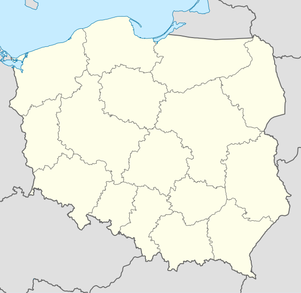
Deutsch: Positionskarte von Polen
Quadratische Plattkarte, N-S-Streckung 160 %. Geographische Begrenzung der Karte:
English: Location map of Poland
Equirectangular projection, N/S stretching 160 %. Geographic limits of the map:
|
||
| Data | |||
| Zdrzōdło |
Włŏsnŏ robota using
|
||
| Autōr | NordNordWest | ||
| Inksze wersyje |
|
||
| SVG rozwój | Ta niezgodna z W3C mapa została stworzona za pomocą Adobe Illustrator
|


Licyncyjŏ
Ja, właściciel praw autorskich do tego dzieła, udostępniam je na poniższych licencjach

|
Danŏ je zgoda na kopiowanie, rozkludzanie i modyfikowanie tego dokumyntu podle warōnkōw GNU Licencji Wolnej Dokumentacji, we wersyji 1.2 abo nowszyj ôpublikowanyj ôd Free Software Foundation; bez niyzmiynnych sekcyji, bez treści wrażōnych na frōntowõ abo zadniõ zajtã ôbkłŏdki. Kopijŏ licyncyje je wrażōnŏ we sekcyji ze tytułym GNU Licyncyjŏ Swobodnyj Dokumyntacyje. |
Tyn zbiōr podlygŏ licyncyji Creative Commons Uznanie autorstwa – Na tych samych warōnkach 3.0.
- Idzie:
- udostympniać – kopiować, rozkludzać i przekazować dzieło
- modyfikować – adaptować dzieło
- Pod tymi warōnkami:
- uznanie autorstwa – Musisz ôkryślić autorstwo, podać link do licyncyje, i skŏzać, czy dzieło było zmiyniōne. Możesz to zrobić kożdym usōndnym spusobym, ale niy tak, żeby sugerować, że posiedziciel licyncyje spiyrŏ Ciebie abo Twoje użycie dzieła.
- trzim licyncyjõ – Jeźli zmiyniŏsz abo budujesz na tyj materyji, musisz swoje dzieło rozkludzać na takij samyj abo zgodliwyj licyncyji, jak we ôryginale.
Możesz ôbrać licyncyjõ.
Gyszichta zbioru
Kliknij w datã/czas, żeby ôbejzdrzeć zbiōr, jak wtynczŏs wyglōndoł.
| Data i czas | Miniatura | Wymiary | Używŏcz | Kōmyntŏrz | |
|---|---|---|---|---|---|
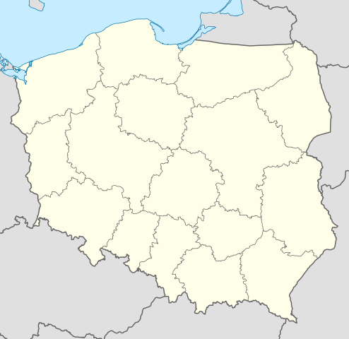
| terŏźnŏ | 14:34, 2 paź 2012 | | 861 × 837 (213 KB) | Palosirkka | Reverted to version as of 20:23, 23 November 2011 Location maps must remain very accurate |
| 22:37, 1 paź 2012 |  | 861 × 837 (196 KB) | Palosirkka | Scrubbed with http://codedread.com/scour/ | |
| 22:23, 23 lis 2011 |  | 861 × 837 (213 KB) | NordNordWest | upd | |
| 13:28, 8 gru 2008 |  | 862 × 838 (377 KB) | NordNordWest | Reverted to version as of 09:25, 8 July 2008, an often used image shouldn't be changed without discussion | |
| 11:26, 8 gru 2008 |  | 862 × 838 (378 KB) | Mareklug | I made the featured background (territory of Poland) pure white for better contrast. | |
| 11:25, 8 lip 2008 |  | 862 × 838 (377 KB) | NordNordWest | {{Information |Description= {{de|Positionskarte von Polen}} Quadratische Plattkarte, N-S-Streckung 160 %. Geographische Begrenzung der Karte: * N: 55.2° N * S: 48.7° N * W: 13.8° O * O: 24.5° O {{en|Location map of Poland} |
Użycie zbioru
Żŏdnŏ strōna niy używŏ tego zbioru.
Globalne użycie zbioru
Tyn zbiōr je używany tyż we inkszych projektach wiki:
- Użycie we ar.wikipedia.org
- Użycie we av.wikipedia.org
- Użycie we bn.wikipedia.org
- Użycie we bs.wikipedia.org
- Użycie we ceb.wikipedia.org
- Użycie we ckb.wikipedia.org
- Użycie we de.wikipedia.org
- Użycie we diq.wikipedia.org
- Użycie we el.wikipedia.org
- Użycie we en.wikipedia.org
- Użycie we en.wikivoyage.org
- Użycie we en.wiktionary.org
- Użycie we eo.wikipedia.org
- Użycie we eo.wikivoyage.org
- Użycie we es.wikipedia.org
- Użycie we fa.wikipedia.org
- Użycie we fo.wikipedia.org
- Użycie we fr.wikipedia.org
- Użycie we hr.wikipedia.org
- Użycie we hsb.wikipedia.org
- Użycie we hu.wikipedia.org
Pokŏż listã globalnego użyciŏ tego zbioru.