
Plik:São Tomé and Príncipe - Location Map (2013) - STP - UNOCHA.svg

Ôryginalny zbiōr (Zbiōr SVG, nōminalnie 250 × 250 pikselōw, srogość zbioru: 348 KB)
_-_STP_-_UNOCHA.svg)
Ôpis
| Ôpis |
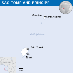
English: Locator map of São Tomé and Príncipe. |
| Data | |
| Zdrzōdło | |
| Autōr | |
| SVG rozwój |
Licyncyjŏ
- Idzie:
- udostympniać – kopiować, rozkludzać i przekazować dzieło
- modyfikować – adaptować dzieło
- Pod tymi warōnkami:
- uznanie autorstwa – Musisz ôkryślić autorstwo, podać link do licyncyje, i skŏzać, czy dzieło było zmiyniōne. Możesz to zrobić kożdym usōndnym spusobym, ale niy tak, żeby sugerować, że posiedziciel licyncyje spiyrŏ Ciebie abo Twoje użycie dzieła.
 This map is part of a collection of 216 free country maps, created by the UN Office for the Coordination of Humanitarian Affairs (OCHA), to be used in print, web or broadcast products.
The ReliefWeb Location Maps released here are maps that highlight a country, its capital, major populated places and the surrounding regions. Attribution Requirements
Using the map without modifications: ensure that the sources and the disclaimer are below the map. Credit as follows: "Credit: OCHA". For use with alteration: remove the OCHA logo and disclaimer following any modification to the map, but keep the data sources as mentioned below the map. Credit the modified map as follows: "Based on OCHA map". You are responsible for the content of your map. We are keen to receive your feedback and hear how you used OCHA's maps. We would be grateful if you would notify us by e-mail and share your work with us. UN Disclaimer
The designations employed and the presentation of material of this map do not imply the expression of any opinion whatsoever on the part of the Secretariat of the United Nations concerning the legal status of any country, territory, city or area or of its authorities or concerning the delimitation of its frontiers or boundaries. |
Gyszichta zbioru
Kliknij w datã/czas, żeby ôbejzdrzeć zbiōr, jak wtynczŏs wyglōndoł.
| Data i czas | Miniatura | Wymiary | Używŏcz | Kōmyntŏrz | |
|---|---|---|---|---|---|
| terŏźnŏ | 08:09, 10 wrz 2016 | | 250 × 250 (348 KB) | Wereldburger758 | Resized page to drawing. Removal watermark. Validation of image. |
| 03:14, 8 mŏj 2014 |  | 254 × 254 (372 KB) | UN OCHA maps bot | == {{int:filedesc}} == {{Information |description={{en|1=Locator map of São Tomé and Príncipe.}} |date=2013 |source={{en|1=[http://reliefweb.int/map/sao-tome-and-principe/sao-tome-and-principe-location-map-2013 Sao... |
Użycie zbioru
Ta strōna używŏ tego zbioru:
Globalne użycie zbioru
Tyn zbiōr je używany tyż we inkszych projektach wiki:
- Użycie we ceb.wikipedia.org
- Użycie we ee.wikipedia.org
- Użycie we en.wikipedia.org
- Użycie we es.wikipedia.org
- Użycie we id.wikipedia.org
- Użycie we pl.wikipedia.org
- Użycie we pt.wikipedia.org
- Użycie we sd.wikipedia.org
- Użycie we te.wikipedia.org
_-_STP_-_UNOCHA.svg)