
Plik:Xinjiang Internment Map, US-Aus Gov Assessment.jpg
Srogość tego podglōndu: 800 x 495 pikselōw. Inksze rozdzielczości: 320 x 198 pikselōw | 640 x 396 pikselōw | 1024 x 634 pikselōw | 1280 x 792 pikselōw | 2048 x 1267 pikselōw.
Ôryginalny zbiōr (2048 × 1267 pikselōw, srogość zbioru: 150 KB, zorta MIME: image/jpeg)
Ôpis
| Ôpis |
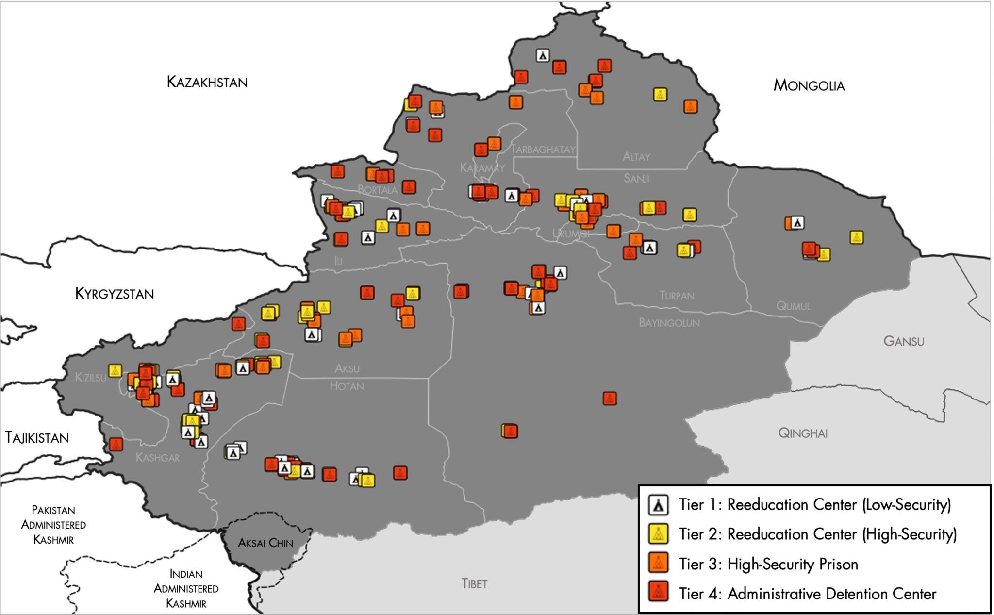
English: Map of the Xinjiang Internment Camps created by the RAND Corporation based on data collected by the US National Geospatial Intelligence Agency and the Australian Strategic Policy Institute. Open source here. |
||||||||
| Data | |||||||||
| Zdrzōdło | https://www.tearline.mil/public_page/xinjiang-nighttime-1/ | ||||||||
| Autōr | National Geospatial Intelligence Agency, using data from the Australian Strategic Policy Institute, and administrative boundaries from GADM. | ||||||||
| Przizwolynie (Użycie tego zbioru) |
|


Gyszichta zbioru
Kliknij w datã/czas, żeby ôbejzdrzeć zbiōr, jak wtynczŏs wyglōndoł.
| Data i czas | Miniatura | Wymiary | Używŏcz | Kōmyntŏrz | |
|---|---|---|---|---|---|
| terŏźnŏ | 07:05, 2 mŏj 2021 | | 2048 × 1267 (150 KB) | Abovfold | Uploaded a work by {{w|National Geospatial Intelligence Agency}}, using data from the {{w|Australian Strategic Policy Institute}}, and administrative boundaries from {{w|GADM}}. from https://www.tearline.mil/public_page/xinjiang-nighttime-1/ with UploadWizard |
Użycie zbioru
Ta strōna używŏ tego zbioru:
Globalne użycie zbioru
Tyn zbiōr je używany tyż we inkszych projektach wiki:
- Użycie we ba.wikipedia.org
- Użycie we br.wikipedia.org
- Użycie we cs.wikipedia.org
- Użycie we de.wikipedia.org
- Użycie we el.wikipedia.org
- Użycie we en.wikipedia.org
- Użycie we es.wikipedia.org
- Użycie we fi.wikipedia.org
- Użycie we fr.wikipedia.org
- Użycie we ga.wikipedia.org
- Użycie we he.wikipedia.org
- Użycie we km.wikipedia.org
- Użycie we nl.wikipedia.org
- Użycie we or.wikipedia.org
- Użycie we pl.wikipedia.org
- Użycie we pt.wikipedia.org
- Użycie we ru.wikinews.org
- Użycie we sv.wikipedia.org
- Użycie we tr.wikipedia.org
- Użycie we www.wikidata.org